A Comparison Of Major Worldviews in the last 2000 years.
Have you ever wondered what it would be like
to have been born into another home, culture,
or religious system?
We’ve all probably questioned what our
beliefs and values would look like through different eyes.
Below is a comparison of major worldviews in the last 2000 years.
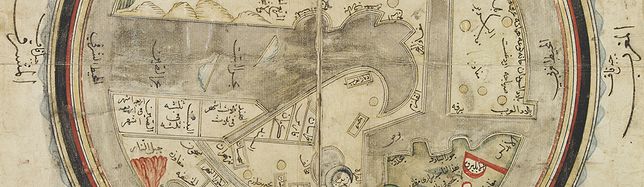
Arabic Cartography, the world centered on Bagdad.
According to Arab geographical theory, based entirely on Ptolemy, this would be a sphere. Since the far side of a
world sphere (an upside-down world) was practically inconceivable, only a single hemisphere was thought to be inhabitable. This could easily be “projected” onto a flat area and represented by a circle.
That Ptolemy represented the inhabitable world as occupying 180 degrees of the earth supported this idea. Thus al-Istakhri represented the world as a circle surrounded by the Encompassing Sea, with the two main seas reaching in from the east and the west toward the center, where they would join except for a small, narrow land barrier—the barzakh of the Qur’an .
By al-Idrisi's time, Muslim astronomers had made great strides in the methods of reckoning latitude. (Longitude remained a problem until the 17th century.) Arab geographers had corrected some of the errors of Ptolemy and other Greek scientists.
The mathematician al-Khwarizmi reduced Ptolemy's estimate of the length of the Mediterranean Sea from 62 to 52 degrees; the Spanish Muslim astronomer al-Zarqali further adjusted the figure to the correct 42. Other Muslim scholars, like the Iraqi astronomer al-Battani and the Persian al-Biruni, composed tables giving the latitudes of leading cities.
 After ISAL-ISTAKHRI. The world, centering on the Persian Gulf. Ottoman province, c. 1820. 260 x 290 mm. World map in manuscript. Drawn on paper with watercolor, ink, gouache and gold highlighting.
Worldmap in manuscript with inscriptions in Arabic showing a map of the world centered on the Jezirah and is based on al-Istakhri's world map (977/1570 A.D). Oriented with South at the top, just as in the T-O maps of contemporary Latin Europe, but instead of the Earthly Paradise, the Arab scholars knew enough to place in the furthest East both China and Tibet.
The map shows Egypt and the river Nile on the right and further on "Country of the Black People". Note how the tip of Africa points eastwards, a mistake which the Chinese geographers were the first to correct.
In the lower right corner is Europe, i.e. "Country of the Romans and Franks".
The map shows the Indus in the lower left, with the Indian Peninsula, Tibet and Chinese Empire and The Red Sea colored in red. The outer circles represent the seas. The manuscript is a cosmology, not meant to be accurate geographically, but only to present the reader with a systematic overview of the existing knowledge about the world at the time.
In his text, al-Istakhri gives a simple description of the world to explain his map. “The earth is divided into two by the two seas so that we have a north or cold half and south or hot half. People in these two halves get blacker as you go south and whiter as you go north etc.”
The main kingdoms are listed together with the kingdoms that adjoin them. This is the only place where non-Islamic areas are given any mention. Measurements are attempted; thus the width from the Encircling Ocean in northwestern Africa to the ocean in China was 400 days’ journey. However, the distance north to south was not measurable. There was a 210-day’ journey through uninhabitable lands, but the extreme north was uninhabited because of intense cold, and the extreme south because of intense heat. The seas were described briefly, and the fact that the Khazar [Caspian] Sea and the Khwarazm [Aral] Sea were landlocked is mentioned, as well as the sea connection between the Encircling Ocean and Istanbul—that is, the Baltic joins up to the Bosporus.
Read more about Islamic cartography.
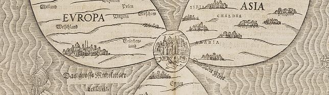
Jerusalem in the center of the World.
Echoing the tripartite division of the T-O conception, the cloverleaf design places Jerusalem firmly in the center of the world, with Rome appearing to have the second degree of importance. The rest of Europe enjoys even less significance, while the Middle Eastern cities of biblical antiquity reflect the most detail.
The three continents of the Old World are well-divided by the seas, but connected by Jerusalem, which served as the hub of the world due to its religious importance, especially during the European Reformation wars. The ocean is titled "The Great Mediterranean Sea of the World"; and the Red Sea is shown separately.
Heinrich Bünting's design was inspired by the trefoil form of the arms of Hanover, his native town. Despite the map's unusual appearance the fact that Jerusalem appears at the center leans strongly on the tradition of medieval world maps.
 BÜNTING, Heinrich. Itinerarium Sacrae Scripturae, das ist, eine Reisebuch über die gantze Heilige Schrifft in zwey Bücher getheilt, de monetis et mensuris sacrae scripturae. Magdebourg, Paul Donat, 1595.
Bunting was born in Hannover, Germany, in 1545 and studied at the University of Wittenberg. He became a pastor at Gronau and a noted Protestant theologian. It is also famous for its image of the continent of Asia depicted as Pegasus. The book is his most famous work and is in fact one of the rarest despite running to a number of editions in different languages.
T–O Map
 This early European world map is called a “T–O Map” because of its symbolic design. Originally drawn in the seventh century as an illustration for an encyclopedia of world knowledge by Isidore of Seville, the design had great religious significance. The “T” represented a Christian cross, placing Jerusalem at the center of the world. It also separated the known continents—Asia, Europe, and Africa.
The “O” enclosing the entire image represented the medieval idea of the world surrounded by water.
Buddhist cosmology.
The Buddhist world maps all represent a large, imaginary India,
where Buddha was born, as the heart of the world, but also depictions of Europe and the New World.
At that time Japan maintained an isolationist policy, which began in 1603 with the Edo period under the military ruler
Tokugawa Ieyasu, and lasting for nearly 270 years. Although knowing the world map by Matteo Ricci, published in Peking in 1602, Japanese maps mainly showed a purely Sino-centric view - or with acknowledgment of Buddhist traditional teaching - the Buddhist
habitable world with an identifiable Indian sub-continent.
 ZUDA ROKASHI (Priest Motan) Nansenbushu bankoku shoka no zu.Kyoto, (Hoei 7 = Year of the Tiger) 1710
This map is a great example of Japanese world maps representing Buddhist cosmology with real-world cartography. It is the earliest one and - therefore - the prototype for Buddhist world maps.
The map was drawn by the scholar-priest Zuda Rokashi, founder of Kegonji Temple in Kyoto, and illustrates the fusion of existing Buddhist and poorly known European cartography. The language is Chinese, except for a few Japanese characters on the illustrations of European countries.
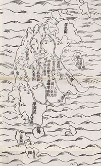 Europe is shown at the upper left as a group of islands, which can be identified from Iceland to England, Scandinavia, Poland, Hungary, and Turkey, but deliberately deletes the Iberian Peninsula. At lower right South America is featured as an island south of Japan with a small peninsula as part of Central America, carrying among just a few place-names also 4 Chinese characters whose phonetical Japanese reading is "A-ME-RI-KA". North of Japan, a land bridge joints Asia with an unnamed landmass, presumably North America. Africa is not shown at all.
On the other hand, this map is much more than a world map and the main
concept by the author was to celebrate a historically very important event. The map echoes the pilgrimage route of the famous Chinese Buddhist priest Hsuan-Tsang (or Xuan Zhuang, Genjo in Japanese, 602-664 A.D.), who traveled to India to visit sacred places of Buddhism and also to collect holy Sanskrit writings. The largest part of the map is depicted as "Jambu-Dvipa," with the sacred Lake of Anavatapta (also known as Lake Manasarovar in the Himalayas) at its center, from which the four rivers —the Ganges, Oxus, Indus, and Tarim — are flowing. This all was based on the Japanese version of Hsuan-Tsang's Chinese narrative, the Si-yu-ki, printed as late as 1653. Here, numerous details are given, including the interesting feature of the so-called "iron-gate", shown as a strongly oversized square, and the path taken by the monk whilst crossing the forbidden mountain systems after leaving Samarkand.
Additionally, in the upper left corner, 102 references from Buddhist holy writings and Chinese annals are listed to enhance the credibility of the map. Folded as usual and mounted on 2 blue cardboards with title-piece (size: 240x180mm, slightly spotted and scraped).
The first Buddhist world map printed in Japan and the prototype for all subsequent Buddhist world maps
printed in Japan until the late nineteenth century. The author, Hotan (1654-1728), was a scholar-priest and founder of the Kegonji Temple in Kyoto. The earliest known example in Japan is the Gotenjiku Zu (Map of the Five Indies) by the priest Jukai, dating from
1364 and now preserved in Horyuji Temple in Nara. However, Hotan’s map was revolutionary in being the first printed Oriental map to introduce detailed Western cartographic information into this traditional Buddhist cosmological view and to attempt to merge the
two together into a comprehensible form. Europe is depicted as a series of islands in the upper left of the image whilst South America is likewise another island in the lower right of the image. Africa is omitted completely. China and Japan are clearly defined in the upper right of the map. The popularity of the map is evidenced by the fact that although the map is dated 1710,
it was reissued unchanged in numerous editions through to about 1815 and spawned innumerable copies and derivatives over the next 150 years. a rare and important cartographic work.
Reference : K Yamashita, Japanese Maps of the Edo Period, pp.32-33 ill. Nanba, Old Maps in Japan ill. 8. K.Unno, Cartography in Japan, 1994, page. 346-477 and illustration 11.59. Cortazzi, Isle of Gold page 38 and col.ill. 48. Beans Coll. 1710.1. Kerlen 44, Muroga & Unno, “The Buddhist World Map in Japan”, in IM XVI (1962). Harley & Woodward, The History of
Cartography, 2.2, pp.428ff and ill.. 11.59.
Map of the world beneath the heavens
The Ch'onhado (hangul:천하도,天下圖, literally "Map of the world beneath the heavens"), or sometimes Cheonha jeondo (hangul:천하전도 ,hanja 天 下 圖, literally "Complete map of the world beneath the heavens), is a peculiar type of circular world map developed in Korea during the 17th century. It is based on the Korean term for map, chido, translated roughly as "land picture".
This manuscript Ch'onhado, or world map, is a very common feature of Korean hand atlases. It is the first map in an Korean atlas and was perhaps copied from a Chinese source. The place names are derived from mythical places noted in Chinese classics and from known lands around China, which occupies the centre of the map. The date of the map is unknown.
 The Ch'onhado maps were created in response to the encounter with Western geographical knowledge, but were based on traditional Asian sources and had an Asian style. The structure of the maps consists of an internal continent with historical place names, an internal sea with place names connected to descriptions of Taoist immortality, an external continent, and an external sea.
The map's structure is straightforward. A central continent, encompassing China, Korea, and several historically significant countries, occupies the center of the circular map, surrounded by an enclosing sea ring that is itself surrounded by an outer land ring. Surprisingly, the maps did not reflect the highest levels of geographic knowledge available to Koreans; however, this is unlikely to be intentional. Some of this was due to the nautical distance between Korea and other Southeast Asian countries.
Asian locales affected the mapmakers' perceptions of Asia. Similarly, European mapmakers of the day often treated Korea as an island.
Some scholars have attributed the development of Korean circular world maps to Western influence, such as the maps of Matteo Ricci (Kunyu Wanguo Quantu) or the maps of Giulio Aleni (Wanguo Quantu). In this case, the central landmass can be viewed as a combination of Asia, Africa, and Europe, and the external "ring" continent as North America and South America.[4]
Such maps were produced in Korea only, and have not been found in China or Japan. The Ch'onhado remained popular in Korea until the late 19th century.
According to Hulbert’s analysis, the central continent represents Asia alone, with India at the southwest
corner. The only rivers definitely given are the Yellow River, the Yang-tse, and the Mekong, all of which are represented fairly well. The general course of these rivers is only approximated here. It is interesting to note that China proper is represented as lying between the Yellow River and the Yang-tse, which, as history proves, was the real birthplace of the Chinese people. Korea and the Yellow Sea are also well represented, but when we go farther afield than this, we find confusion. Annam is not far out of the way, but the land to the west of it, which must represent Siam [Thailand] and Burma, is highly fanciful. The water to the east of India must be the
Bay of Bengal, and the two forks at the head of it may represent the Irrawaddy and Salween Rivers. If this is so, the Kwen-lun Mountains are not far enough out of their proper place to call for severe criticism. Using a liberal imagination, the unnamed lake to the north of these mountains may represent the Caspian Sea. The name of the map is placed at the two upper corners and means Under the Heavens and The Whole Map.
The Dutch World view
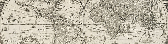
The Dutch Golden Age saw map-making reach a fever pitch of creative and commercial ambition. This was the era of the first-ever atlases - elaborate, lavish and beautiful. This was the great age of discovery and marked an unprecedented opportunity for mapmakers, who sought to record and categorize the newly acquired knowledge of the world.
Dutch maps influenced the world as far as Japan. One of the treasures of the Kobe City Museum is a screen decorated with a map of the world. On the reverse, there are four cities and figures in different costumes. This screen is based on a wall map of the world by Willem Jansz Blaeu, of 1607.
In 1644 the governor-general requested new presents for Japan: among these a silver ship for the young shogun, several large globes and two large maps of the world. He said he wanted the kind of map typically seen in Dutch houses, hanging on the wall like a painting. The maps should be decorated with figures in costumes of the different nations in the world. But, he added, please be careful that there are no crucifixes or saints depicted on the maps. The governor-general did not want to provoke the Japanese, who had just thrown out the Catholic Portuguese.
Dutch maps were copied in England, Germany, Italy and France. A curious example is a map by Antoine de Fer, published in Paris in 1645. Although it was copied extensively from Visscher's map, de Fer enlisted Willem Blaeu in the title. According to Tooley, presumably, it was because the name of Visscher did not carry sufficient international status. As a matter of fact Blaeu's map was largely available in Paris at this time, which could not be said for Claes Jansz. Visscher or his maps. As a matter of fact, the figured border maps for which C.J.Visscher was renowned seem to be a typical Dutch product not used in France. The map is therefore one of the first of few examples of such a map that was produced in France.

DE FER, A. - Nouvelle et exacte description du globe terrestre reveue corrigée et augmente´e suivant les derniéres relations des Anglais et Hollandois. Par Guillaume Blaeu 1645. Published : Paris, 1645.
Size : 17.1 x 21.9 inches. / 43.5 x 55.5 cm.
Extremely rare and decorative "carte à figures" world map published by Anthoine de Fer. Henri le Roy has engraved the map. Antoine de Fer copied the map after Claes Jansz. Vischer's World map of 1638.
The partial outline of Australia may well have been derived from Blaeu, whose firm was in the possession of revised information by the mid-1640s.
California has also been amended to appear as an island. Interestingly he ads "Californie Isle long 1700 lieus".
See our section of world maps for sale.
See episode from BBC's documentary series charting the visual appeal and historical meaning of maps.
See how cartography has changed and entered an age of digital map-making. Denis Lawson explains how digital mapping is shaping the future, letting us see into virtual spaces and into the infinite unknowns of outer space.
Each image is a breathtaking first look at the world today, showing the extent of human endeavour in the most beautiful ways possible.
Google's New Map of Global Cyber-Attacks
As part of a summit on cyber-conflict today, Google and Arbor Networks released a map (see above) that visualizes major cyberattacks around the world as they occur. Specifically, the map tracks distributed denial-of-service attacks (DDoS for short), in which a large number of machines work together to overload or otherwise foul up a given Web server. The goal is generally to take a website or Web service offline, or slow it down to the point of unusability.
