Browse Listings in Asia > Thailand / Burma / Vietnam
![XIX. Venatio Elephantum in Pegu. [How elephants are caught in Pegu]](/uploads/cache/29795-250x250.jpg)
XIX. Venatio Elephantum in Pegu. [How elephants are caught in Pegu]
How elephants are caught in Pegu. The king of Pegu had a particular method of transporting elephants. He had a great enclosure built of strong wooden posts, with a trap d...
Date: Frankfurt, 1599
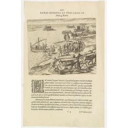
XV. Ratio Homines Ex Uno Loco In alium gestandi.
Scene in the kingdom of Pegu, now Myanmar, showing elephant, ships and locals.Theodore de Bry, a German engraver and book dealer, began a compilation of early voyages in ...
Date: Frankfurt, 1599
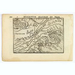
Aracam.
A rare miniature map of Thailand and Burma. Title cartouche on the upper left corner. First published in 1598 in his 'Caert-Thresoor', the plates were executed by the mos...
Date: Amsterdam, 1606
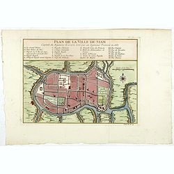
Plan de la ville de Siam.
Early plan of Siam, Thailand. Across the top is an extensive list of 22 important sites and locations keyed to the plan with tiny letters and numbers.Jacques Nicolaas Bel...
Date: Paris, 1750

The East Part of India, or India beyond the R. Ganges.
Herman Moll's map of those Asian countries to be found east of the River Ganges, including Burma, Thailand, Vietnam, Laos, Cambodia, southern most China, Malaysia, Sumatr...
Date: London, ca 1750
![[Lot of 4 charts] Plan de la Baie et du Port de Camraigne / Plan de la Baie de Niatrang et du Golfe de Binkang / Plan de la Cote de Cochinchine. . . / Plan des Ports de Xuandai, Vung-Lam. . .](/uploads/cache/44795A-250x250.jpg)
[Lot of 4 charts] Plan de la Baie et du Port de Camraigne / Plan de la Baie de Niatrang et du Golfe de Binkang / Plan de la Cote de Cochinchine. . . / Plan des Ports de Xuandai, Vung-Lam. . .
[A set of four French sea charts numbered consecutively]. A set of 4 basic coastal sea charts of parts of southern French Indochina (Vietnam).Chart 295 centers on the reg...
Date: Paris ca 1780

Carte routière de l'Indochine. Des kilomètres en sécurité sur Goodrich.
Advertising poster for the brand Goodrich, showing a map of Indochina.Goodrich Corporation is a former American company specializing in civil and military aeronautical eq...
Date: Paris, ca 1934
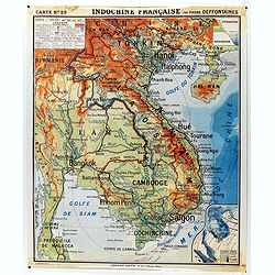
Indochine française. Carte N° 29.
School map of Indochina by Pierre Deffontaines Agréée d'Histoire et de Géographie Docteur es Lettres, published c. 1940 by "Librairie Hatier". Scale : 1:1 60...
Date: Paris, c. 1940

Plan commercial de la Région Saïgon-Cholon.
Decorative publicity plan of Ho Chi Minh City, also known by its former name of Saigon and Cholon, prepared by Ngo-Trinh, surrounded by advertisements of local stores. Th...
Date: Saigon, 1948
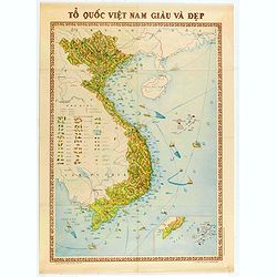
To Quoc Viet Nam Giau Va Dep (Vietnam).
Economic map of Vietnam published in 1976.Features Vietnam, Cambodia, Laos and part of Thailand. With a key referring to agricultural productions and fauna…The map show...
Date: Hanoï, 1976

