Browse Listings in Asia > Philippines
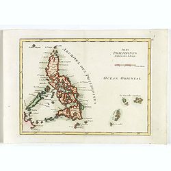
![Les Isles Philippines [on sheet with] Islas de los Ladrones ou Isle des Larrons.](/uploads/cache/42023-250x250.jpg)
Les Isles Philippines [on sheet with] Islas de los Ladrones ou Isle des Larrons.
Sanson's important mid-seventeenth-century map of the Philippines and tha Ladrones.It was first engraved by J. Somer for the elder Nicolas Sanson with a privilege for twe...
Date: Amsterdam/Utrecht, 1654
![[The Philippines]](/uploads/cache/49201-250x250.jpg)
[The Philippines]
Fine chart depicting the Islands of the Philippines. Little interior detail is given but the coastlines, settlements and principal coastal features are identified. An att...
Date: Amsterdam, 1724
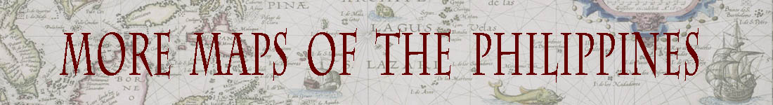
Insulae Palaos seu Novae Philippinae 87 Alias Archipelagus S. Lazari ven Carolinae . . .
Map of Philippine archipelago. Stöcklein's work is a compound of letters of the Jesuit missionaries from all over the world and here particularly the ones stationed at t...
Date: Augsburg, 1726
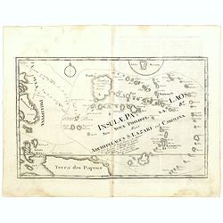
Plan de la Baye de Manille. / Plan van de Baay van Manilla.
Detailed plan of Manila Bay after George Anson's key plan of the Bay of Manila. With a compass rose and soundings in the Bay. East to the top.This is the rare Dutch editi...
Date: Amsterdam, Arkstee and Merkus, 1751
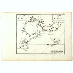
Isles Philippines.
Fine map of the Philippines. George Louis Le Rouge was active from 1740- till 1780 as a publisher, and was appointed engineer for the King of France. From his Atlas Nouve...
Date: Paris, 1756
Isles Philippines.
Fine map of the Philippines. George Louis Le Rouge was active from 1740- till 1780 as a publisher, and was appointed engineer for the King of France. From his Atlas Nouve...
Date: Paris, 1756

Costumes des habitans de Manille.
A very beautiful print, showing four elegant figures relaxing in a shady glade, two women recline and two stand chatting.After a design of Duché de Vancy and engraved by...
Date: Paris, 1798

Vue de cavite dans la Baie de Manille.
Two boats and passengers with Cavite Philippines in the background as if was seen from Manila Bay in January 1787. After a design of Gaspard Duchè de Vancy and engraved ...
Date: Paris, 1798
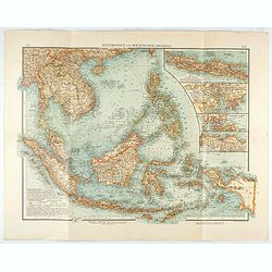
Hinterindien und Malayischer Archipel.
Map of South East Asia with four insets. Shows settlements, roads, railways, telegraph cables, etc. A color key to Dutch, French, British, and Portuguese occupations. Inc...
Date: Leipzig, 1905
![Manila the perl of the Orient. Guide book to the intending visitor [with several photos and 3 plans of Manila]](/uploads/cache/48356-250x250.jpg)
Manila the perl of the Orient. Guide book to the intending visitor [with several photos and 3 plans of Manila]
Charming 1908 Guide book to with several photos and 3 folding plans of Manilla. Published by the "Manila merchants' association", directed by O'Connell, Daniel....
Date: Manilla, 1908

Philippines Islands.
Pictorial map of Philippines Islands, from the famous illustrator, Ruth Taylor White and published in "Our USA: A Gay Geography".Ruth Taylor White was among the...
Date: Boston, Little, Brown and Company, 1935
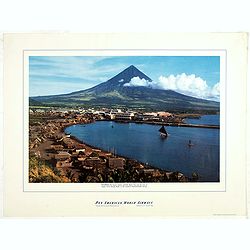
Philippines - The famous volcanic peak Mt. Mayon. . .
Mt Mayon Volcano Peak near Legaspi on the Philippines. Fine Pan American Airline mini poster.Pan American World Airways, originally founded as Pan American Airways and co...
Date: 1956
Selling price: ????
Please login to see price!
Sold in 2023
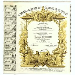
Compania General De Tabacos De Filipinas - (Certificate) Accion ordinarias de 500 Pesetas, Barcelona, 27.10.1969.
Beautifully engraved certificate from the Compania General De Tabacos De Filipinas issued in 1985. This historic document has an ornate border around it with a vignette o...
Date: Barcelona, 1969
