![.Taprobana Ins. Tabula XII Asiae. [Sri Lanka.]](/uploads/cache/27928-250x250.jpg)
.Taprobana Ins. Tabula XII Asiae. [Sri Lanka.]
Ptolemy's mythical island of Taprobana originally became associated with Sri Lanka although it was sometimes confused with Sumatra. Taprobana, as it was called on most ea...
Date: Lyons, M. Servetus, 1535
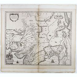
![.[Bangladesh, Burma, India, Thailand]](/uploads/cache/33867-250x250.jpg)
.[Bangladesh, Burma, India, Thailand]
Wood block printed map and one of earliest printed representation of Bangladesh, Burma, India, Thailand prepared Martin Waldseemüller. Based on the slightly larger map f...
Date: Vienna, Trechsel, G., 1525 -1541
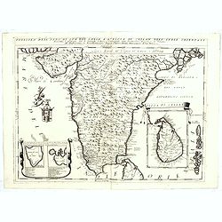
![.[India]](/uploads/cache/33861-250x250.jpg)
.[India]
Wood block printed map and one of earliest printed representation of India prepared by Martin Waldseemüller. Based on the slightly larger map from 1513 published in &quo...
Date: Vienna, Trechsel, G., 1525 -1541
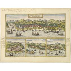
Calechut Celeberri mum Indiae Emporium/ Ormus/ Canonor, St.Georgii.
Four panoramic town-views on one sheet: The upper approximately two-thirds of this double-page sheet contains a fine panoramic view of Calicut which is on the west coast ...
Date: Cologne, 1580
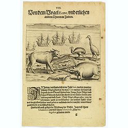
The bird called 'Eeme' and other creatures of India.
Especially on the island of Java and in India, a strange bird called an 'Eeme' is found. It is almost as large as an ostrich with strong and sturdy legs, but it has no to...
Date: Frankfurt, 1598
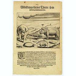
Some of the animals that are found in India.
Although most elephants are found in Ethiopia, there are also many in India too. They are called 'Caffres' by the inhabitants and are slaughtered for their tusks, which t...
Date: Frankfurt, 1598

Maldivae Insulae.
Very fine early miniature map of Maldives Islands. East is at the top. Title cartouche on the lower right corner. A dolphin and two ships are depicted.First published in ...
Date: Amsterdam / Frankfurt, 1609
![Narsinga. [India]](/uploads/cache/38123-250x250.jpg)
Narsinga. [India]
Small map illustrating the Indian peninsular. Oriented with East on top, surrounded by text in Dutch.Nicolaes de Clerck (de Klerc) was active as engraver and publisher in...
Date: Amsterdam, Cloppenburch, 1621
Malabar.
Small map illustrating the south western seacoast of India. Oriented with East on top, surrounded by text in Dutch.Nicolaes de Clerck (de Klerc) was active as engraver an...
Date: Amsterdam, Cloppenburch, 1621

India Orientalis.
Published in Hondius' editions of the Mercator Atlas from 1606 onwards, showing the Indian subcontinent, the Malay Peninsula, Siam and Cambodia, China and the Philippines...
Date: Amsterdam, 1630
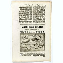
Magni Mogolis Imperium.
Important map of India, based upon William Baffin's map of India, first published in about 1619. The map is bounded by Pakistan, Afghanistan and Bangladesh and extends in...
Date: Amsterdam, 1650
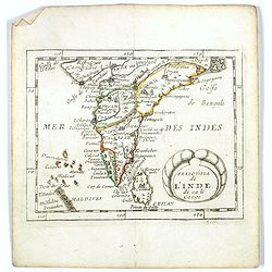
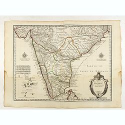
Presqu''isle de L'Inde de ça le Gange.
Uncommon miniature map of India from Pierre Duval's La Geographie Universeille dated 1676. Following his Cartes de geographie in 1657, Pierre Duval published this smaller...
Date: Paris, 1676

Le Grand Mongol. . .
Rare full portrait of the Mongol emperor of Indostan, published by map seller, François Jollain, the Elder (1641-1704), active in Paris, rue St. Jacques à la ville de C...
Date: Paris, ca. 1686
Penisola dell'Indo di qua del Gange, e l isola di Ceilan..
India below the Tropic of Cancer, with an inset of Ceylon and Trincomalee.The remarkable Vincenzo Coronelli (1650-1718), encyclopaedist, geographer, inventor and Doctor o...
Date: Venice, 1698
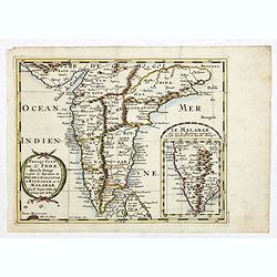
Presqu Isle de L'Inde. deca la Gange.. .
Two maps together on one sheet. General map showing the southern part of India, including the northern part of Shri Lanka. In an inset a detailed map of the most southern...
Date: Amsterdam, 1700
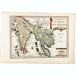
Les Vrays Indes dits Grands Indes ou Indes Orientales Par N. de Fer. Geographe de Sa Majeste Catoliques et de Monseigneur le Dauphin.
Detailed map on India, Thailand, the Malay Peninsular and the south coast of China up to Macao. The map was engraved by C. Inselin.
Date: Paris, 1705
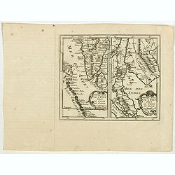
Prequ Isle de L'Inde deca Le Golfe du Gange (and) Prequ Isle de l'Inde dela le Golfe du Gange.
A very rare double map of India, Sri Lanka and the Maldives islands, together with a separate map of Cambodia, Thailand, Malaysia and North Sumatra. The map shows Bangkok...
Date: Brussels, Antwerp, 1706

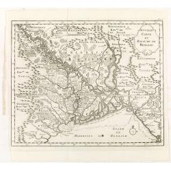
De golf van Bengalen.
Rare chart of the Indian Ocean, with nice detail on Ceylon (Sri Lanka) with compass roses and a system of rhumb lines, soundings and anchorage's. Many place names. The pl...
Date: Amsterdam, after 1669-1712

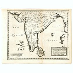
Carte du Golfe de Bengale, mer des Indes et rivieres du Gange . . .
Detailed scare map of the Southern part of India with Ceylon. Good detail along the coasts of Malabar, Coromandel, the Maldives islands and the Kingdoms of Visipour, Golc...
Date: Leiden, 1719
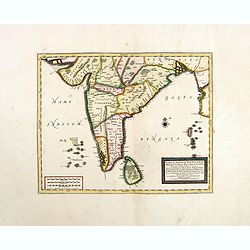
Carte du Golfe de Bengale, Mer de Indes, et Riviere du Gange, Avec les Pais et Iles d'alentour, Savoir les Cotes de Malabar, Cormandel, Ile de Ceylon, Les Maldives . . .
Detailed map of the Southern part of India with Ceylon. Good detail along the coasts of Malabar, Coromandel, the Maldives islands and the Kingdoms of Visipour, Golconda, ...
Date: Leiden, 1719
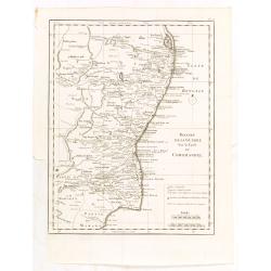
Carte des Cotes de Malabar et de Coromandel..
Detailed and attractive map of India and the northern tip of Sri Lanka. With decorative title cartouche and two compass roses.Rare edition with address : A Paris chez l�...
Date: Paris, 1723

Nieuwe kaart van 't Koninckryk Bengale. . .
Rare map Bangladesh with the Ganges delta, including Calcutta. Giving great detail with trade routes, European trade settlements, etc. Prepared by Joh. Van Leenen who was...
Date: Amsterdam, 1726
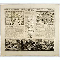
Genealogie des empereurs Mogols . . .
Text sheet with two inset maps of "Carte de l'empire du grand Mogol (122x158mm.) and inset map of Kahsmire "carte nouvelle du royaume de Kachemire" (120x15...
Date: Amsterdam, 1728

Carte nouvelle des Terres de Cucan..
Prepared by H.Reland (1676-1718) a professor active in Utrecht and specialized in Asian languages, geography and religions. His first map was a map of Japan copied after ...
Date: The Hague, 1728

Vorstellung der Evangelisch-Ostindischen Kirche Augsburger Protestanten.
It is a very decorative and rare print to commemorate the 200-year Confession of the Augsburg Protestant Confession. Engraved by J. Kleinschmidt after a design of E. Ridi...
Date: Augsburg, 1732
Mogol.
A very nice map of Northern India and Pakistan. From Francisco Giustiniani for El Atlas abreviado o el nuevo compendio de la Geografia universal, politica, historica, i c...
Date: Leon de Francia (Lyon), Jaime Certa, 1739
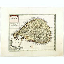
Isola Ceilon.
Attractive copper engraved map of Sri Lanka showing mountains, Towns and the Rama's Bridge (Ponte di Adamo). Included in "Atlante Novissimo che Contiene Tutte le Par...
Date: Venice, 1740
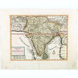
Impero del Gran Mogol.
Attractive copper engraved map of India with Sri Lanka. Showing mountains, towns and the Rama's Bridge (Ponte di Adamo). Included in "Atlante Novissimo che Contiene ...
Date: Venice, 1740

Cochin (today: Ernakulam)
Small but charming 18th water color on paper depicting Cochin (today : Ernakulam) was from 1500, when the first Portuguese fleet called on its port, a firm ally of the Po...
Date: India? c.1750
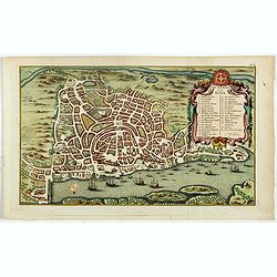
Grundriss von Goa.
A beautifully detailed and engraved town-plan of the Portuguese colony of Goa in India, with a number key (1-29) to the city's major monuments and sites, enclosed in a de...
Date: Amsterdam, 1752

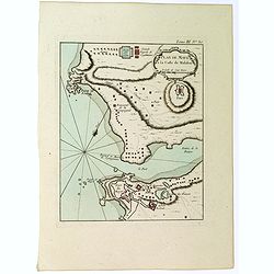
De Zuydwest-Kust van Het Eyland Ceylon.
A finely engraved and detailed chart of Nilwella / Kudawella Harbor.Very rare: only included in the 6th volume (so-called secret atlas) of Van Keulen's. A lettered key in...
Date: Amsterdam, 1753
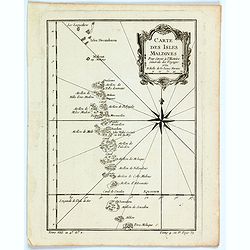
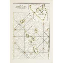
Carte des Isles Maldives.
A small detailed map of the Maldives, with rhumb lines and a large compass rose. Includes a decorative title cartouche. One of the maps produced by Nichlas Bellin for Pre...
Date: Paris, 1757
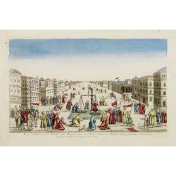
La Feste du Poids au Mogol qui se célebre chez ses Peuples avec grande vénération.
So-called optical print illustrating a perspective view of a square in Mongolia.Mondhare, active at rue St.Jacques a l'Hotel Saumur, was a well-known publisher of optical...
Date: Paris, 1760
Theatre de la guerre sur la coste de Coromandel.
Map of Coromandel coast prepared by J.N.Bellin.
Date: Amsterdam, Leipzig, 1763
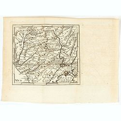
Nouvelle carte du royaume de Bengale.
Map of Bengal Kingdom prepared by J.N.Bellin.
Date: Amsterdam, Leipzig, 1763
Plan de Maye a la Coste de Malabar.
From Bellin's 'Le Petit Atlas Maritime', a plan of the bay of Maye, off the Malabar coast of southern India. Relief shown pictorially. It shows settlements, ports, and ma...
Date: Paris, 1764
Carte des Isles Nicobar... (with) Plan particulier du Port compris entre les Isles Nacaveri, Souri, et Tricutte.
French chart of Isles of Nicobar in Gulf of Bengal near Birmanie and Sumatra. Prepared by Jacques-François L'Abbé Dicquemare (1733-1789). Latitude and longitude scales,...
Date: Paris, Brest, chez Demonville, 1775
![ИНДIИ [Map of India in Cyrillic].](/uploads/cache/44340-250x250.jpg)
ИНДIИ [Map of India in Cyrillic].
A map of India. This Cyrillic version of the map appeared in one of the first world atlases published in Russia, "Novy Atlas, ili sobranie kart ..." which trans...
Date: Paris / St.Petersburg, ca. 1790

A chart of the northern part of the Indian Ocean..
Complete title in upper right "A Chart of the Northern Part of the Indian Ocean, Containing a Part of the Coast of Africa from Magadasho River to the Straits of Bab-...
Date: London 1794
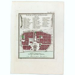
Plan de la ville de Pondicheri.
The first detailed French plan of Pondicherry. In the lower part, a lettered and numbered key and the coat of arms of Mr. Joseph-François Dupleix.The Compagnie des Indes...
Date: Paris, 1800

Recueil de cartes géographiques pour la description de l'Indostan . . .
First French edition, the maps revised by Jean Nicholas Buache. The English original edition was published in London in 1783 by Brown under the title "Memoir of a ...
Date: Paris, Poignée, an VIII = 1800
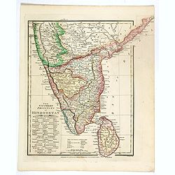
The Southern provinces of Hindoostan . . .
An attractive map showing Hindoostan and Ceylon. Shows towns, rivers, mountains, lakes, etc. In pretty original wash colors. Robert Wilkinson was active in London as a ca...
Date: London, 1808
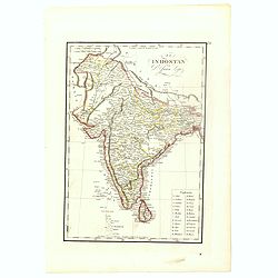
![Hindostan [India]](/uploads/cache/49208-250x250.jpg)
Hindostan [India]
A fine copper engraved map of Hindoostan (now India) drawn and engraved by Alexander Findlay and published by Thomas Kelly, London in 1814
Date: London, 1814
El Indostan por D. Juan Lopez.
Uncommon map of India and Shri Lanka published by Juan Lopez (1765-1830) and included in his "Atlas Universal o collection de mapas nuevos. . ." first published...
Date: Madrid, 1817
Carte De L'Indostan Servant à Indiquer Les Possessions Françaises En Asie.
Map of a part of Asia, with Sri Lanka, From " Nouvel Atlas du royaume de France, ou cartes détaillées des Gaules, de la France à l'époque de 1789, des 86 départ...
Date: Paris, 1826
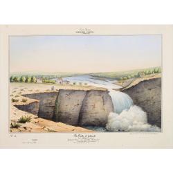
Southern - Concan.. - The falls of Gokank..
Hand colored lithography representing a view of the Gokak Falls, located on the Ghataprabha River. The Ghataprabha river in India is an important right-bank tributary of ...
Date: Paris, 1843

Un Reclutatore in India. Papagallo No. 42. Anno VI.
A British recruter in India. Design by Augusto Grossi. Taken from the Italian satirical newspaper Il Papagallo, a satirical magazine founded in January 1873 by Augusto Gr...
Date: Bologne, 1878
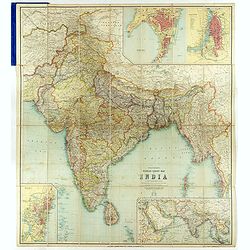
Thacker's Reduced Survey Map of India.
Thacker's reduced Survey Map of India prepared by John Bartholomew and published n Calcutta by Thacker, Spink, & Co. And W. Thacker & Co. in London in 1914.This e...
Date: Calcutta: Thacker, Spink, & Co./ London : W. Thacker and Co., 1914

Outposts of Empire. Ceylon.
A large colored lithograph by John Vickery (1906-1983), he was an Australian artist. He worked in the fields of painting, illustration and advertising. He is the only Aus...
Date: London, ca 1937
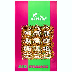
Inde.
Decorative poster advertising flights to India made by Georges Mathieu. The poster is one of a series of 15 composed of posters of Greece, Israel, Germany, Great Britain,...
Date: Paris, 1967
![[Afghanistan].](/uploads/cache/44611-250x250.jpg)
[Afghanistan].
A scarce Russian relief map (in Russian) of Afghanistan published in Moscow during the Soviet occupation of the country during the early 1980s. Complete with a separate b...
Date: Moscow, 1982
