"Mer de L'Ouest" or "Sea of the West"
Mer de l'Ouest ("Western Sea"), originally the goal of EXPLORATION during the French regime, was the stuff of wishful thinking, obligingly corroborated by Indians. Initially thought to be an
inland sea somewhere west of the Great Lakes, it gradually blended in imagination with the Pacific. The search for the Mer de l'Ouest had a useful function, since the argument that exploration must be financed by the FUR TRADE served ambitious traders well in their efforts to secure monopoly privileges from the royal authorities.
The imaginary Mer de l'Ouest finally came to rest in the region around Lake Winnipeg, where, in the middle of the buffer zone marked off by the Cree and Assiniboine around the English at Hudson Bay, LA VÉRENDRYE, his sons and their successors established a network of trading posts after 1730.
Good reading.
Lucie Lagarde, “Le Passage du Nord-Ouest et la Mer de l’Ouest dans la Cartographie Française du 18e Siècle,
Contribution à l’Etude de l’Oeuvre des Delisle et Buache, Imago Mundi, Vol. 41 (1989), pp. 19-43.
Hayes, Derek, Historical atlas of the Pacific Northwest, p. 18-27.
Petty, C. M., When France was King of Cartography, p. 113 – 164.
Kellog, L. P., The French Regime in Wisconsin and the Northwest.
Winsor, Justin, The Mississippi Basin: The Struggle in America Between England and France 1697 – 1763.
New.
 Just released by MapRecord Publications, the publication of The Last Great Cartographic Myth: Mer de l'Ouest,
a digital-format cartobibliography, written by Don McGuirk. This is a groundbreaking work, not just in terms of being the first published cartobibliography covering the Mer de l'Ouest, but also in terms of being the first cartobibliography published in this electronic format.
Just released by MapRecord Publications, the publication of The Last Great Cartographic Myth: Mer de l'Ouest,
a digital-format cartobibliography, written by Don McGuirk. This is a groundbreaking work, not just in terms of being the first published cartobibliography covering the Mer de l'Ouest, but also in terms of being the first cartobibliography published in this electronic format.
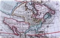
Carto-bibliographies have been a vital source of information about antiquarian maps for collectors, researchers and map dealers. For example, no fewer than three carto-bibliographies have been published about what is perhaps the best-known cartographic myth: California as an island. Throughout the 18th century another myth appeared on maps of North America: Mer de l'Ouest (Sea of the West), an imagined sea extending the navigable waters of the Pacific deep into the North American continent, at times nearly connecting the Pacific to Hudson Bay or the
Great Lakes, and thereby promising the long sought for Northwest Passage from the Atlantic to the Pacific.
Don McGuirk has collected and researched maps that depict the Mer de l'Ouest, and he has now written a
cartobibliography covering the entire history of this fascinating cartographic delusion. The
cartobibliography lists 239 maps (many in multiple states), and most of the entries are accompanied
by one or more high-resolution images.
The publication date of The Last Great Cartographic Myth: Mer de l'Ouest is March 15, 2011. The purchase
price is $45, plus $2 for shipping/handling.